
Ground-station Marcs
Owner N5FXH
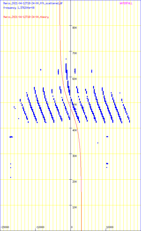
Waterfall
DopplerComparaison
PostProcessing
satellite NOAA_15
date 2021-04-12
time 18:24:00
duration 900
freq 1.3762e+08
culm 86.836
The graph at the bottom left gives the waterfall (time on the abscissa, frequency on the ordinate). The graph at the top gives the integrated signal strength in frequency as a function of time. At the bottom right, the average of the spectra over all the measurement times (frequency on the ordinate).
The time range of the measurement is given in the top right part (minimum_time, maximum_time). The frequency range determined by the number of points used by the Fourier transform is given by fmin and fmax. The units used for power (or the energy received in each time slot) could not be determined.
transitfile record.Marcs.2021-04-12T18-24-00.transit
The beginning of the transit is marked by a circle and the end of the transit by a disc.
![]()
When the intensity of the signal as a function of time follows an approximately Gaussian law, this tool must capture approximately the parameters by non-linear adjustment. The adjustment is carried out using the NLOPT2 library. The behavior is undefined if the law is arbitrary.

abscisses: giga-samples name ordinates: sum_20000(I2+Q2)/1e6
Abscissa: frequency in Hz
Ordinates: time in seconds
sumY2 1.07519e+13
sumDy2 1.12318e+13
dfmin -354.976 sumDy2 1.1194e+13
dtmin -14.2102 sumDy2 1.11698e+13
name ‘NOAA_15’
satellite_number 25338
central_object EARTH
ephemeris_type UnknownEphemerisType
epoch_year 21
epoch_day 101.85048243
Kepler elements
epoch_julday 2459316.35048243
Time jd 2459316.35048 < 2021-04-11 20:24:41.0681 UTC >
inclination 98.6891 deg [98 41'21"]
right_ascension_of_ascending_node 130.949 deg [8:43:48]
major_radius 7184.01 km
eccentricity 0.0011524
periast_argument 113.115 deg [113 06'53"]
mean_anomaly 247.1249 deg [247 07'30"]
Supplemental data
cc 1.99769785299
ra 7.19229e+06 [821282]
rp 7.17573e+06 [804725]
va 7458.64
vp 7441.47
axb 7192.29 x 7192.29
mammmdt 99.593
bstar 0.1804
mean_motion_1st_deriv 3.2e-07
mean_motion_2nd_deriv 0
mean_motion 14.2602 rev/day 0.0701252 day/rev
periapsis_distance 7175.73 km
apoapsis_distance 7192.29 km
periapsis_mean_height 804.725 km
apoapsis_mean_height 821.282 km
rev_number_at_epoch 19175
tle_age 0.696173 day
NOAA 15
1 25338U 98030A 21101.85048243 .00000032 00000-0 31804-4 0 9995
2 25338 98.6891 130.9492 0011524 113.1146 247.1249 14.26021533191751
median 30.603
noise_level_db 30.6651
min 20.0182
max 57.4832
freq_center -13699.4
trig_level_db 10
nbin_rescaling 29.9957
freq_center_trig -1737.52
signal_range_dB 26.8181
theo_range_dB 48.1648 [ 8 bits ]

Carte meteo WXTOIMG RESTORED v.2.10.11 https://wxtoimgrestored.xyz/
N5FXH’s page