Ground-station Satnogs-VHF
Owner N5CNB
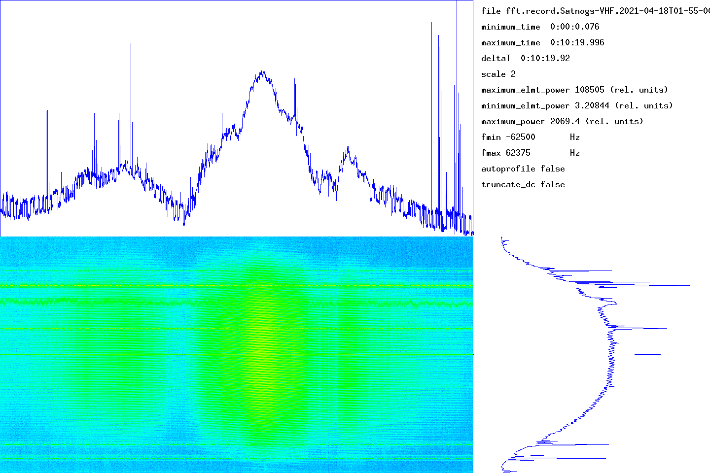
Waterfall
DopplerComparaison
PostProcessing
satellite METEOR-M_2
date 2021-04-18
time 01:55:00
duration 620
freq 1.371e+08
culm 54.4195
The graph at the bottom left gives the waterfall (time on the abscissa, frequency on the ordinate). The graph at the top gives the integrated signal strength in frequency as a function of time. At the bottom right, the average of the spectra over all the measurement times (frequency on the ordinate).
The time range of the measurement is given in the top right part (minimum_time, maximum_time). The frequency range determined by the number of points used by the Fourier transform is given by fmin and fmax. The units used for power (or the energy received in each time slot) could not be determined.
transitfile record.Satnogs-VHF.2021-04-18T01-55-00.transit
The beginning of the transit is marked by a circle and the end of the transit by a disc.
![]()
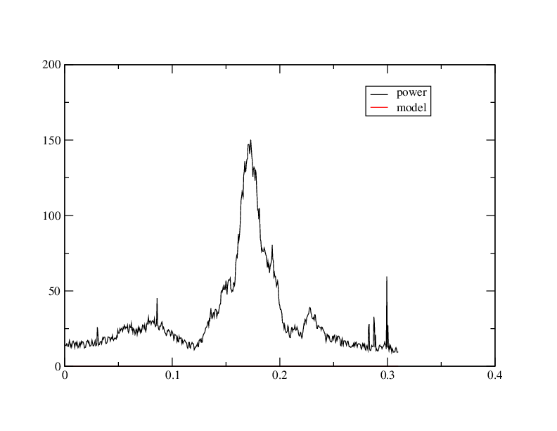
When the intensity of the signal as a function of time follows an approximately Gaussian law, this tool must capture approximately the parameters by non-linear adjustment. The adjustment is carried out using the NLOPT2 library. The behavior is undefined if the law is arbitrary.
abscisses: giga-samples name ordinates: sum_20000(I2+Q2)/1e6
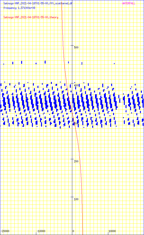
Abscissa: frequency in Hz
Ordinates: time in seconds
sumY2 3.89197e+13
sumDy2 3.92585e+13
dfmin 348.566 sumDy2 3.9116e+13
dtmin -0.505762 sumDy2 3.91158e+13
name ‘METEOR-M_2’
satellite_number 40069
central_object EARTH
ephemeris_type UnknownEphemerisType
epoch_year 21
epoch_day 107.23279661
Kepler elements
epoch_julday 2459321.73279661
Time jd 2459321.73280 < 2021-04-17 05:35:13.0627 UTC >
inclination 98.4677 deg [98 28'04"]
right_ascension_of_ascending_node 138.709 deg [9:14:50]
major_radius 7202 km
eccentricity 0.0006837
periast_argument 115.149 deg [115 08'56"]
mean_anomaly 245.0399 deg [245 02'24"]
Supplemental data
cc 1.99863353425
ra 7.20692e+06 [835912]
rp 7.19707e+06 [826064]
va 7445.83
vp 7435.66
axb 7206.92 x 7206.92
mammmdt 87.1243
bstar 0.5864
mean_motion_1st_deriv -7e-08
mean_motion_2nd_deriv 0
mean_motion 14.2068 rev/day 0.0703887 day/rev
periapsis_distance 7197.07 km
apoapsis_distance 7206.92 km
periapsis_mean_height 826.064 km
apoapsis_mean_height 835.912 km
rev_number_at_epoch 35134
tle_age 0.478558 day
METEOR-M 2
1 40069U 14037A 21107.23279661 -.00000007 00000-0 15864-4 0 9997
2 40069 98.4677 138.7087 0006837 115.1490 245.0399 14.20683506351344
median 14.7
noise_level_db 14.3986
min 5.06294
max 50.3545
freq_center 6731.9
trig_level_db 10
nbin_rescaling 29.9957
freq_center_trig 6370.28
signal_range_dB 35.9559
theo_range_dB 48.1648 [ 8 bits ]
Carte meteo METEOR_DEMOD https://github.com/dbdexter-dev/meteor_demod
Carte meteo METEOR_DECODER https://github.com/artlav/meteor_decoder
N5FXH’s page