Ground-station Satnogs-VHF
Owner N5CNB
Waterfall
DopplerComparaison
PostProcessing
satellite METEOR-M_2
date 2021-04-20
time 01:15:00
duration 620
freq 1.371e+08
culm 58.7672
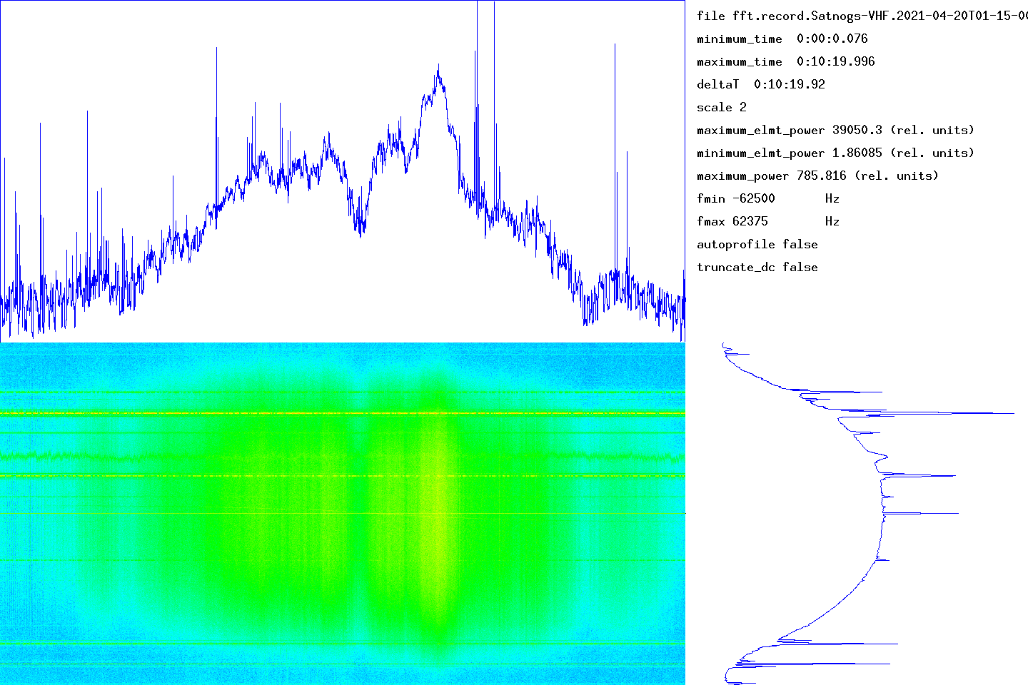
The graph at the bottom left gives the waterfall (time on the abscissa, frequency on the ordinate). The graph at the top gives the integrated signal strength in frequency as a function of time. At the bottom right, the average of the spectra over all the measurement times (frequency on the ordinate).
The time range of the measurement is given in the top right part (minimum_time, maximum_time). The frequency range determined by the number of points used by the Fourier transform is given by fmin and fmax. The units used for power (or the energy received in each time slot) could not be determined.
transitfile record.Satnogs-VHF.2021-04-20T01-15-00.transit
The beginning of the transit is marked by a circle and the end of the transit by a disc.
![]()
When the intensity of the signal as a function of time follows an approximately Gaussian law, this tool must capture approximately the parameters by non-linear adjustment. The adjustment is carried out using the NLOPT2 library. The behavior is undefined if the law is arbitrary.
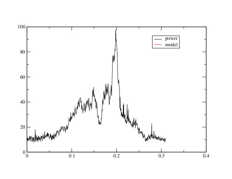
abscisses: giga-samples name ordinates: sum_20000(I2+Q2)/1e6
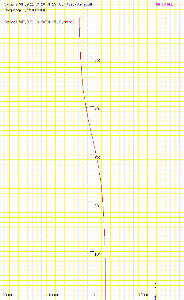
Abscissa: frequency in Hz
Ordinates: time in seconds
sumY2 1.51706e+08
sumDy2 1.07228e+06
dfmin 81.8735 sumDy2 882.308
dtmin 0.0141859 sumDy2 867.422
name ‘METEOR-M_2’
satellite_number 40069
central_object EARTH
ephemeris_type UnknownEphemerisType
epoch_year 21
epoch_day 108.71179909
Kepler elements
epoch_julday 2459323.21179909
Time jd 2459323.21180 < 2021-04-18 17:04:59.0441 UTC >
inclination 98.4674 deg [98 28'03"]
right_ascension_of_ascending_node 140.126 deg [9:20:30]
major_radius 7202 km
eccentricity 0.0006869
periast_argument 111.496 deg [111 29'46"]
mean_anomaly 248.6947 deg [248 41'41"]
Supplemental data
cc 1.99862714302
ra 7.20694e+06 [835936]
rp 7.19705e+06 [826042]
va 7445.86
vp 7435.63
axb 7206.94 x 7206.94
mammmdt 86.5954
bstar 0.00897
mean_motion_1st_deriv -3.7e-07
mean_motion_2nd_deriv 0
mean_motion 14.2068 rev/day 0.0703887 day/rev
periapsis_distance 7197.05 km
apoapsis_distance 7206.94 km
periapsis_mean_height 826.042 km
apoapsis_mean_height 835.936 km
rev_number_at_epoch 35155
tle_age 0.618363 day
METEOR-M 2
1 40069U 14037A 21108.71179909 -.00000037 00000-0 20897-5 0 9991
2 40069 98.4674 140.1259 0006869 111.4961 248.6947 14.20683209351557
median 13.1693
noise_level_db 12.6583
min 2.69713
max 45.9162
freq_center 8409.66
trig_level_db 10
nbin_rescaling 29.9957
freq_center_trig 9599.47
signal_range_dB 33.2579
theo_range_dB 48.1648 [ 8 bits ]

Carte meteo METEOR_DEMOD https://github.com/dbdexter-dev/meteor_demod
Carte meteo METEOR_DECODER https://github.com/artlav/meteor_decoder
N5FXH’s page